SSURGO Soils Map 2026: Transforming Precision Agriculture
“By 2026, SSURGO soils maps cover over 95% of U.S. farmland, powering high-tech precision agriculture decisions.”
In the evolving realm of agriculture and land management, the importance of understanding soil at a granular level cannot be understated. The SSURGO soils map stands as a transformative digital tool—driving innovation, sustainability, and productivity in modern farming, forestry, and environmental management across the United States. As we move into 2026, the integration of SSURGO data with advanced technologies propels precision agriculture to new heights, enabling smarter, more sustainable practices across millions of acres.
This comprehensive guide delves into the SSURGO soils map, exploring its purpose, structure, applications, current advances, and why it continues to revolutionize productivity, conservation, and decision-making for farmers, agronomists, and land planners in the future.
“SSURGO data features over 300 unique soil properties, integrating advanced analytics for smarter land management in modern agriculture.”
What is SSURGO? The Digital Cornerstone of Precision Agriculture
SSURGO (Soil Survey Geographic Database) is a digital soil survey database maintained by the Natural Resources Conservation Service (NRCS) under the USDA. It provides detailed, spatially referenced soil information for specific locations—most typically, field and county-sized regions across the United States.
As of 2026, the SSURGO soils map is the leading source for high-resolution soil data, encompassing critical soil characteristics such as texture, drainage, organic matter content, pH, and much more. This high degree of granularity enables valuable insights for farmers, foresters, conservationists, mining experts, and land managers seeking to implement targeted and sustainable practices.
SSURGO Soils Map: The Essentials
- Origin: Developed and maintained by NRCS (USDA)
- Coverage: Over 95% of U.S. farmland by 2026
- Resolution: Down to field and sub-field level (granular)
- Accessibility: Integrated into modern GIS and remote sensing platforms
Significance of the SSURGO Soils Map in Modern Agriculture and Land Management
The importance of the SSURGO soils map is underscored by its direct impact on precision agriculture, environmental conservation, and resource management. By providing detailed, spatially referenced soil data, SSURGO enables highly informed management and planning decisions for fields, farms, and even entire regions.
SSURGO’s hyper-local detail enables precision agriculture—allowing for real-time, sub-field decisions that were impossible with older, broader mapping methods.
The SSURGO soils map offers unique strengths compared to legacy mapping systems:
- Allows farmers to identify soil properties at the individual field level
- Foresters can select species based on highly localized soil characteristics
- Mining operators can assess potential extraction risks and environmental impacts
- Conservationists can implement more effective land restoration and erosion control practices
- Government agencies and planners can monitor, evaluate, and regulate land use with accurate, up-to-date datasets

Comparative Features Table: Traditional Soil Mapping vs. SSURGO-Integrated Digital Mapping
| Mapping Method | Data Resolution | Update Frequency | Integration with Technology | Estimated Cost Savings for Farmers | Environmental Impact |
|---|---|---|---|---|---|
| Traditional Soil Mapping | 1–10 km² per unit | Every 5–10 years | Limited | Up to 5% | Moderate reduction |
| SSURGO-Integrated Digital Mapping | Down to 0.5 km² or even finer | Real-time, annually, or as needed | High | Up to 15% | Significant reduction |
Integrating SSURGO data with GPS and modern farm management software amplifies its benefits—unlocking even greater operational efficiency and resource savings.
How SSURGO Data Drives Precision Agriculture in 2026
Precision agriculture relies on detailed, site-specific soil data to maximize productivity while minimizing environmental risks. The SSURGO soils map is the digital backbone enabling this shift from guesswork to granular decision-making.
- Guides variable rate technology (VRT) applications for fertilizer, seed densities, and irrigation
- Helps farmers select crop types matched to precise soil characteristics
- Reveals detailed data on organic matter content, pH levels, texture, and drainage
- Enables real-time monitoring of soil health and crop suitability across the landscape
- Supports technology integration with drones, remote sensing, and IoT field sensors

SSURGO Soils Map and Variable Rate Technology (VRT)
- ✔ Precise targeting of fertilizer and water, reducing input costs and runoff.
- 📊 Data-driven planting: Adjusting seed densities for optimal yield across diverse soil types.
- 🛡 Reduced environmental impact: Applying nutrients only where needed, minimizing losses to the environment.
- ⚠ Lowered erosion risks: Directing conservation efforts precisely using accurate SSURGO mapping.
- 🧑🌾 Empowered farmers: Making granular, real-time decisions with confidence and information.
Using outdated or low-resolution soil data. Modern precision agriculture demands high-detail, regularly updated datasets like the SSURGO soils map.
SSURGO Soils Map: Empowering Farmers and Agronomists in the United States
- Farmers in the Midwest utilize SSURGO to manage irrigation water efficiency for corn and soybeans.
- Viticulturists in California’s wine regions use SSURGO to match vine varieties to soil pH and texture.
- Dairy operators in Wisconsin optimize nutrient management to minimize runoff into sensitive watersheds.
No matter the region, the SSURGO soils map provides the granular insight needed to tailor agricultural applications for the exact conditions present beneath every field.
- ✔ Enhanced productivity: Data-driven planting boosts yield
- 📈 Reduced input costs: Optimized fertilizer and irrigation applications save resources
- 🛡 Environmental stewardship: Precision applications reduce nutrient runoff and emissions
- 📊 Better risk management: Erosion and drought vulnerabilities addressed using accurate soil assessments
- 🧑🌾 Empowered farmers: Real-time adjustments via Apps like Farmonaut ensure adaptability for every season
Technology advancements have increased the ROI on precision agriculture tools that utilize SSURGO data—yield improvements, reduced costs, and sustainability compliance are all measurable outcomes powering agri-tech investments.


SSURGO and Sustainable Farming Practices
Sustainability is at the heart of 2026’s most effective farming systems. The SSURGO soils map provides the scientific baseline for sustainable practices—empowering farmers, conservationists, and planners to reduce inputs, conserve water, and protect natural resources.
- Conservation tillage: Identifying low-erosion risk fields using accurate slope and texture data
- Carbon sequestration: Evaluating soil organic matter content for climate-smart farming strategies
- Water management: Pinpointing fields with poor drainage or compaction, and adjusting practices accordingly
- Pollution prevention: Implementing buffer strips and contouring based on erosion-prone soil types
- Soil health monitoring: Real-time assessments of nutrient and organic carbon levels for adaptive management
Curious how your farm’s carbon footprint is impacted by soil management? Explore Farmonaut’s Carbon Footprinting solution—designed to track emissions, monitor soil carbon, and support global agri-sustainability targets.
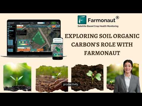
With over 300 unique soil properties per SSURGO soil map region, sustainable management becomes truly customized—enabling nuanced, field-specific conservation efforts.
SSURGO for Environmental Conservation and Land Management
Environmental management teams and conservationists depend on accurate soil mapping to restore native habitats, reverse degradation, and fortify ecosystems against climate change. The SSURGO soils map stands at the forefront in these sectors by offering:
- Precise delineation of erosion-prone zones
- Targeted placement of buffer strips, wetlands, and conservation forests
- Support for watershed planning and stormwater management projects
- Baseline data collection for environmental impact assessments
Need supply chain traceability from soil to shelf? Farmonaut’s Blockchain-Based Traceability Solution ensures transparency and authenticity throughout your agricultural operations—empowering farmers, retailers, and conscious consumers.
Visual List: SSURGO Enables Smart Environmental Restoration
- 🌱 Restoring wetlands by mapping hydric soils
- 🌳 Strategic re-planting on highly eroded sites based on SSURGO data
- 🌊 Improving watershed health via soil permeability and drainage class mapping
- 🔥 Fire resilience planning in forests using SSURGO-supported soil moisture insights
SSURGO in Forestry and Mining: Resource Planning, Risk, and Environmental Impact
The SSURGO soils map is not confined to agricultural circles. In both forestry and mining exploration, SSURGO data delivers critical site information—informing which species to plant, identifying hazards, and supporting compliance with environmental regulations.
Forestry Applications: Species Suitability & Wildfire Management
- Foresters use SSURGO to match tree species to exact soil pH and drainage
- Thinning and diversity planning guided by sub-field soil characteristics
- Wildfire risk assessment based on soil moisture retention from SSURGO
- Long-term health and carbon sequestration projections depend on detailed, up-to-date soil information
If you manage large-scale plantations or require forest advisory services, you’ll benefit from Farmonaut’s Plantation & Forest Advisory solutions—designed for scalable, satellite-driven insights across vast regions.
Mining & Minerals Exploration: Environmental Compliance and Cost Efficiency
- Precise overlay of soil types for smarter exploration and reduced rehabilitation costs
- Soil texture and drainage data guide pollution, leachate, and reclamation planning
- Supports EIAs (Environmental Impact Assessments) for permits and regulation
- Innovations in site monitoring using real-time platforms reduce compliance burdens and enhance risk management
For mining or agricultural operators needing reliable documentation for loans and insurance, Farmonaut offers satellite-based verification, boosting your access to capital while minimizing fraud and streamlining compliance.
Technology Integration: How Modern Platforms Transform SSURGO Use
The full potential of the SSURGO soils map is unlocked via integration with modern technologies: satellite imagery, machine learning, IoT field data, and comprehensive GIS systems. As we look to 2026 and beyond, accessible platforms—like those provided by Farmonaut—deliver affordable, highly scalable solutions grounded in SSURGO.
- Remote Sensing: Satellite images reveal real-time vegetation and soil moisture dynamics, layered with SSURGO data for rapid decision-making
- AI and Machine Learning: Models identify productivity hot spots, optimize planting times, and flag anomalies across massive regions
- Blockchain Traceability: Ensures transparent tracking from soil to harvest, critical for compliance and export markets
- Cloud-Based Platforms: Deliver on-demand access to maps, analytics, and advisory tools from any device

Farmonaut: Satellite-Driven SSURGO Soil Mapping and Next-Gen AgTech
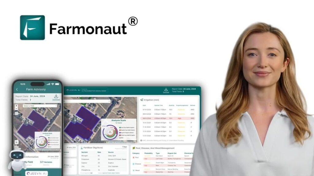
At Farmonaut, we leverage satellite imagery, AI, and blockchain to extend the power of SSURGO soils map for next-generation precision agriculture, mining, and land management worldwide. Our goal is to make data-driven insights affordable, scalable, and actionable for businesses, users, and governments.
- Satellite-Based Monitoring: Real-time updates on crop health, soil moisture, and field conditions, integrated with SSURGO datasets
- AI-Based Advisory: Our Jeevn AI system delivers real-time, tailored guidance using soil, weather, and remote sensing data
- Blockchain Traceability: Tools for tracking product journeys, ensuring authenticity for supply chains: see our product traceability solutions
- Fleet & Resource Management: Logistics optimization, asset tracking, and efficiency tools: Explore fleet management
- Environmental Impact Monitoring: Measuring and minimizing carbon footprints: Understand our monitoring solutions

Our robust API and mobile/web platforms make SSURGO-integrated insights accessible anywhere, anytime. Learn more on our API page and API Developer Docs.
Our subscription model provides flexible, scalable access to field monitoring, traceability, and real-time analytics—empowering users to upgrade as their needs grow.
Managing large farms? Optimize your portfolio with Farmonaut’s Large-Scale Farm Management platform—track thousands of acres, monitor real-time conditions, and streamline your operations from one dashboard!
Common Challenges & The Future of SSURGO Soils Mapping
While the SSURGO soils map offers unmatched granularity, challenges remain:
- Data updates may lag behind rapidly changing land uses
- Subtle intra-field soil transitions sometimes require on-ground validation
- Historic data gaps in certain regions, though these are narrowing quickly
- Integration with new field-level or 3D soil profiling technologies
The future for SSURGO is bright:
- More frequent updates and crowd-sourced field validation
- Pairing soil microbiome analysis with spatial data for advanced soil health metrics
- Improved satellite and UAV imagery for on-demand, field-level mapping
- AI-powered predictive models driving further optimization of planting, irrigation, and input strategies
Staying at the technological forefront requires not just accessing SSURGO data, but integrating it with satellite-driven, AI-enhanced analytics—solutions that Farmonaut constantly innovates for our users.
Leverage both SSURGO and real-time, ground-truthing platforms for holistic land management in an era when climate, policy, and market conditions shift rapidly.
FAQs about SSURGO Soils Map: Everything Modern Land Managers, Farmers, and Planners Need to Know
What is the main advantage of SSURGO soils map compared to traditional soil surveys?
The SSURGO soils map provides highly detailed, spatially-referenced data down to the sub-field or plot level, allowing farmers, planners, and environmental managers to make precise, data-driven decisions. Traditional maps often lack this granularity and are updated less frequently.
How is SSURGO soils map data integrated with modern technologies?
SSURGO is digitally compatible with GIS, satellite monitoring, AI advisory systems, and mobile/web apps. Integration enables real-time monitoring, predictive analytics, traceability, and streamlined operations—key for modern precision agriculture and resource management.
What types of information does SSURGO provide?
SSURGO datasets include over 300 soil properties—such as texture, drainage class, pH, organic matter, and erosion potential—indexed at high spatial resolutions. This comprehensive data supports specific decision-making for agriculture, forestry, mining, and conservation.
Can SSURGO soils map help with compliance and traceability?
Yes. By documenting field and crop-level soil data, SSURGO supports evidence-based regulation, environmental audits, and end-to-end product traceability—especially when paired with platforms using blockchain technology.
How do I access and utilize SSURGO-enhanced solutions?
Access is simple and scalable via platforms like Farmonaut—available on web, Android, and iOS—integrating SSURGO data with real-time satellite, analytics, and advisory tools designed for farmers, businesses, and governments.
Overlooking proper integration of SSURGO data with real-time remote sensing sources—always ensure your farm management platforms synchronize multiple data streams for complete visibility!
Conclusion: SSURGO Soils Map—The Future of Agricultural Innovation, Sustainability, and Land Management
In 2026 and beyond, the SSURGO soils map stands as a pillar of precision agriculture, environmental conservation, and sustainable land management. By bringing together over 300 unique soil properties in a detailed, accessible format, SSURGO empowers farmers, planners, foresters, and businesses to drive productive, resilient, and environmentally responsible practices.
The combination of SSURGO with modern technologies—including AI, satellite monitoring, blockchain, and advanced advisory tools—marks a new era in agriculture and resource management. With leaders like Farmonaut making once-elite technology available and actionable for everyone, the barriers to sustainable and optimized land use are rapidly falling away.
As the digital transformation of agriculture accelerates, the SSURGO soils map remains the strategic cornerstone, driving informed, innovative, and sustainable decisions for years to come.
For developers and agri-businesses: Explore our API • See API Developer Docs